
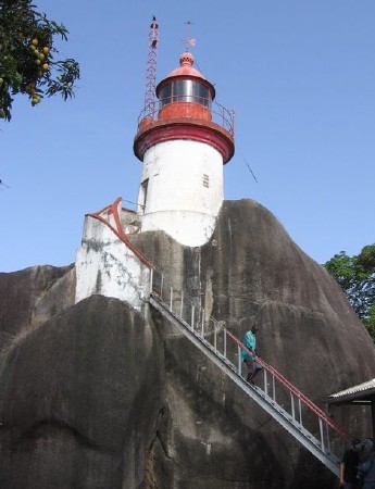
Île Tamara Lighthouse
 | |
| Location | Îles de Los, Conakry Guinea |
|---|---|
| Coordinates | 9°27′29″N 13°50′01″W / 9.457960°N 13.833648°W |
| Tower | |
| Constructed | 1906 |
| Construction | masonry tower |
| Height | 10 metres (33 ft) |
| Shape | cylindrical tower with balcony and lantern |
| Markings | white tower, red balcony and lantern |
| Light | |
| Focal height | 95 metres (312 ft) |
| Range | 26 nautical miles (48 km; 30 mi)[1] |
| Characteristic | Fl W 5s. |
The Île Tamara Lighthouse is a lighthouse in Guinea.[2][3][4][5] It was constructed on Île Tamara, outermost of the Îles de Los, in 1906, and has been active since that time. It serves as the landfall light for Conakry. The lighthouse tower itself is only 33 feet (10 m) tall; however, as it was constructed on top of a large boulder, its focal plane is considerably higher, at 311 feet (95 m).
References[edit]
- ^ "Lighthouse Explorer". Archived from the original on 22 February 2016. Retrieved 4 February 2016.
- ^ Rowlett, Russ. "Lighthouses of Guinea". The Lighthouse Directory. University of North Carolina at Chapel Hill. Retrieved 4 February 2016.
- ^ United States. Hydrographic Office (1942). Sailing Directions for the West Coasts of Spain, Portugal, and Northwest Africa and Off-lying Islands: The Coasts of Spain and Portugal from Cabo Toriñana to Cabo Trafalgar, the Madeira Group, the Azores, Canary Islands, Cape Verde Islands, and the West Coast of Africa from Cape Spartel to Cape Palmas. H.O. pub. U.S. Government Printing Office. p. 384. Retrieved 15 May 2019.
- ^ Sailing Directions (enroute): West Coast of Europe and Northwest Africa. Pub. (United States. Defense Mapping Agency. Hydrographic/Topographic Center). The Agency. 2000. p. 237. Retrieved 15 May 2019.
- ^ Pielow, C.L. (2001). Guide to Port Entry. Shipping Guides Limited. p. 952. Retrieved 15 May 2019.
External links[edit]
- Île Tamara Lighthouse in Lighthouse Digest's Lighthouse Explorer Database
- Picture of the Île Tamara Lighthouse
| Authority control databases: Geographic |
|---|
This lighthouse-related article is a stub. You can help Wikipedia by expanding it. |
This article about a Guinean building or structure related topic is a stub. You can help Wikipedia by expanding it. |